YOUR BUSINESS AUTHORITY
Springfield, MO
YOUR BUSINESS AUTHORITY
Springfield, MO
The city of Springfield has released a draft of its comprehensive plan for the next two decades. Titled Forward SGF, the 250-page document outlines a wide-ranging vision for the city and includes 10 main goals, which Springfield Business Journal is unpacking in this series. This is the fifth installment. Catch up on coverage at SBJ.net/ForwardSGF.
The Forward SGF comprehensive plan was born from the input of residents, and one message that came through loud and clear was their desire for connection.
Specifically, residents asked for connections in the city’s trail system and for neighborhoods to have more connections to the trails.
“Neighborhoods should be connected to the trail system by sidewalks and multiuse paths,” the draft of the plan states. “Future residential development should be encouraged near Springfield’s existing trails, as well as parks and natural areas, to better connect residents to recreational opportunities and destinations across the city via walking and biking.”
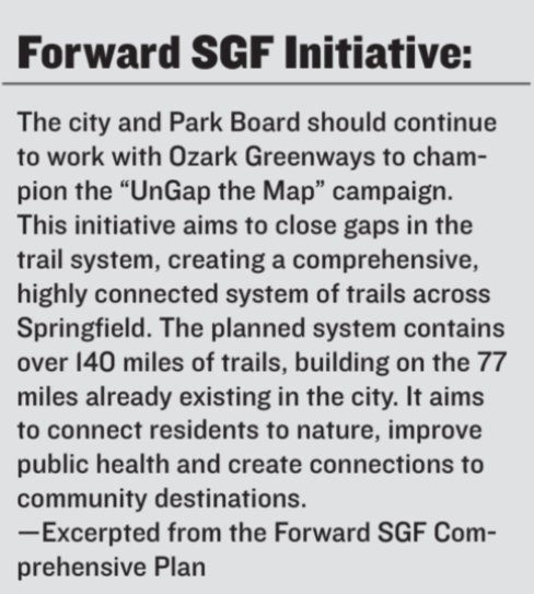
The plan specifically calls on support for projects like Grant Avenue Parkway, a multimodal path that will connect Sunshine Street to downtown walkers, bikers and drivers, and like UnGap the Map, an initiative of Ozark Greenways Inc., whose mission is to connect the community via trails.
Within Springfield, 77 miles of trail already exist, according to Forward SGF, and the planned system will nearly double that to over 140 miles.
Mary Kromrey, executive director of Ozark Greenways, said she was thrilled but not surprised to see UnGap the Map included in the Forward SGF draft. After all, the previous comprehensive plan, Vision 2020, identified opportunities for trails that are still under development.
“As our community changes, we are seeing where we need to have new trail connections, and where maybe some that were forecast to be needed 20 years ago aren’t needed,” she said.
Trails should go where population growth is occurring, according to Kromrey.
There are plans for expansion to many of the existing trails. One example is the Fassnight Creek Greenway, which extends from Fassnight Park to Phelps Grove Park and will eventually reach west to Jordan Creek and Wilson’s Creek greenways and east to the Springfield Art Museum. City Council approved a $460,000 bid for the project Sept. 19.
Another example is the $20 million Chadwick Flyer Trail, the biggest so far for Ozark Greenways, now under development to hook up the city of Ozark with the Lake Springfield area.
Trails serve to connect people from Point A to Point B, and they also connect people with nature. At their best, trails serve both aims.
Kromrey said trails are being used more often for transportation – something she said is a beautiful thing.
“As we fill our gaps in our planned system, that connectivity is going to be able to increase,” she said.
The proposed plan
Forward SGF calls for further trail connectivity through a partnership of the city, the Springfield-Greene County Park Board, Ozark Greenways and the Ozarks Transportation Organization, as well as private developers.
“Existing trail plans should be integrated and streamlined to provide for a focused regional approach for the development of a variety of trails,” the plan states. “This effort could lead to one of the most robust and diverse trail systems in the country.”
The plan calls for older, existing parks to be enhanced through the addition of perimeter trails.
The plan also suggests efforts be made to connect Springfield’s trails with regional efforts in southwest Missouri and northwest Arkansas as part of a wider campaign for outdoor lifestyles and ecotourism.
In addition to trail development, the comprehensive plan promotes filling gaps in the city’s sidewalk system and improving wayfinding to direct residents and visitors to parks, trails, recreational facilities and natural areas.
Public-private partnerships have built most of Ozark Greenways trails, Kromrey said. For example, about a mile and a half of paved-trail gap on the Fulbright Spring Greenway was filled in 2020. Ozark Greenways was the project manager and lead; the city was the landowner, and Ozark Greenways raised public and private funds for construction. The Springfield-Greene County Park Board maintains and manages the trail.
Another example is the Fellows Lake trails. City Utilities of Springfield owns the land, while the organization TrailSpring funded the building of the trails. Ozark Greenways maintains and manages the trails, Kromrey said.
A means of connection
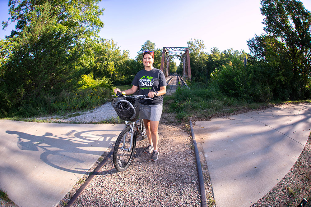
Angela Kersten Jackson is a committed user of the Ozark Greenways trail system. She likes to commute to her job as executive assistant at Kuat Innovations LLC, a company that manufactures bike racks for vehicles.
Kuat, located near the Partnership West Industrial Park, is nearly 8 miles from Jackson’s home north of Hillcrest High School. Jackson travels by The Link, which consists of cycle-friendly roadways, as well as the trail system to get to her office.
Jackson said one part of the UnGap the Map plan would provide a welcome connector between Kearney Street and her work.
“This is something I would use on a daily basis,” she said.
Bikes also provide a favorite recreational option for Jackson, her husband and their five kids. On a recent Monday, she noted she and her husband were planning to bike from their home to go out for a date night.
Frequently, Jackson rides on the roads, though she says she much prefers the safety and ease of a trail.
“If we do have an opportunity to take a greenway, it’s safer, and cars are happy when they don’t have to deal with bikes on the road,” she said.
Kromrey noted the trail system isn’t just for cyclists. People often walk and use wheelchairs on the trails.
“As more people are looking toward having options in their transportation, they want to be able to get somewhere by bike, car, bus or walking,” she said. “Greenways trails are a comfortable place to be able to do that. The streets aren’t very friendly for people on bicycles.”
She said greenways trails are most commonly paved trails located along urban streams. Some trails are unpaved with a natural surface, and some are even water trails for canoers or kayakers.
“We are very car-centric here. This could help change that,” Kromrey said. “Trails aren’t going to solve all transportation problems. Nor are sidewalks. Nor are roads. Nor is transit.”
A complete system
While Jackson likes the term UnGap the Map, she thinks there is another way to look at the issue.
“Think about the map as not being gapped but being incomplete,” she said. “Any time you can actually connect more points on a map, you’re connecting parts of the community. You’re not just connecting neighborhoods; you’re connecting neighborhoods to schools, places to go to eat and spend money.”
Jackson said she and her husband were talking about a possible bikepacking trip.
“We don’t even really have to go down to Arkansas for that,” she said. “We could start from our house, ride out to the Frisco Trail and take that up to Bolivar. There’s a new section from Bolivar to Clinton; then we could get on the Katy Trail and go right on over to St. Louis. Just think of it – we could go from our house to St. Louis by bike.”
She noted a lot of bike trails, like the Katy Trail and the planned Chadwick Flyer extension, are built along former railways.
“I love the thought that they’re still connecting communities,” she said.


A franchise store of a Branson West-based quilting business made its Queen City debut; Grateful Vase launched in Lebanon; and Branson entertainment venue The Social Birdy had its grand opening.
$2M in tax credits awarded to SWMO nonprofits
Baldwin, Lathan to chair United Way campaign
Produce recall impacts food sold at Walmart, Aldi and Kroger
Mixed-used development proposed in KC area
Tax deduction program for farmers set to launch
Report: Panera explores sale of Caribou Coffee, Einstein Bros Bagels